So how do you get from North Carolina to Brazil? Apart from the general “are you crazy,” this is the most common question we get when people find out about our trip. Whether out of fascination or morbid curiosity, people want to know. Honestly, this is a question we ourselves have spent a long time trying to figure it out, so we’re going to try to break it down for you. Two continents and eleven countries. That’s what stands between us and the 2014 World Cup.

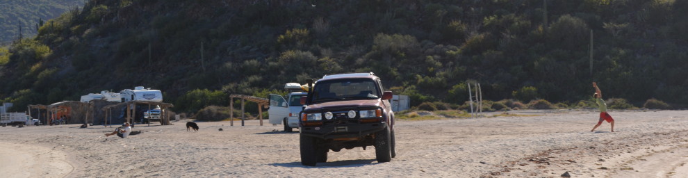
The first one is the easiest. From Durham it’s a quick shot across I-85 until Atlanta, then another short ride heading into Texas. “Quick” is relative, but this is one of the easy parts of our trip. Nothing against the southeastern United States, but we’re hoping to make up some serious road time by burning across this first part of our trek. From there, we take the first real step into the adventure: crossing the border into Mexico. Passing through Laredo, our drive through Central America sets off, taking us through Monterrey, and off cruising down the eastern part of the country. Like the section in the states, we are hoping to make our way through Mexico quickly. We have a pretty tight window to get to Brazil, so we’re looking for any chance we can to make up time on the road. Large and safe toll highways in Mexico are just the thing we need to rack up some serious mileage.

On to Guatemala. Assuming we make good time through the border crossing, we get to take our first rest day at Lake Atitlan. After a few days of heavy driving this scenic mountain lake should provide the perfect backdrop from some much needed r and r. Quick dip, quick nap, then it’s back to the grind. From here we’ll pass through Honduras, Nicaragua, and Costa Rica in our never-ending journey south. We’re crossing our fingers that road and traffic conditions are forever in our favor as we finally head to Panama, the last stop in the Central America portion of our journey.
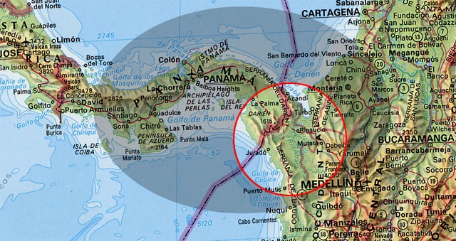
The Darien Gap
There is, however, a slight obstacle when it comes to driving across the Americas: You physically can’t. That’s thanks to a pesky little patch of land called the Darien Gap. This 100 mile stretch separates Panama and Colombia, and is the only piece of land connecting North and South America. One side is swamp, the other side is mountains, and there are zero roads through it. As a result, somewhere in Panama we will be loading the Land Cruiser into a shipping container and waving goodbye as it makes the voyage alone to Colombia, where we will meet it, fill out pages of paperwork, and then continue on our way.
From Colombia it’s off to Ecuador, down the Pan-American Highway, and then into Peru. Easily said in a few words, but this portion of our trip will take days of heavy driving through some of the America’s most historically significant locales. From Quito, the world’s highest capital, down the Peruvian coast and into the Incan heartland, this stretch of the trip has captured adventurers’ spirits for centuries. While unfortunately we won’t have time to stop everywhere, hopefully we will get to see at least some of the gorgeous locations as we pass through towards our final destination.
Halfway through Peru we will head east towards the interior of the continent, and towards another unknown: the Amazon. Reaching the border is only the beginning of the end of our journey, as we will still have several days of driving through the famous rainforest to make our final stop. If everything goes to plan, we will be in Cuiaba, Brazil on June 17th, in time to make our first match of the tournament. Once we make it to Cuiaba, our trip is just beginning. Games will take us to the eastern coast in Recife and Natal, and hopefully back down to Rio to catch the final games in the group stage. When’s its finally all said and done, the Landcruiser will once again board a ship and make the long journey back to the states. THis time, though, we will hop on a plane ourselves and fly back. After weeks of driving, hopefully we’ll have earned it.
We have thousands of miles of road to traverse, and inevitable unknown obstacles along the way. It won’t be easy, but hey, at least we have a game plan.
Updates: Check out the live map at map.brazildrive.com ! Code for generating your own map can be found at https://github.com/grantfowler/node-spot-map .
This is so awesome what you guys are doing and with such a cool land cruiser. Have fun and play safe. Keep a journal and take lots of good photos.
Safe travels always,
Fellow travellers, Tom and Janet